
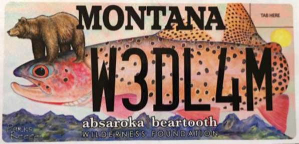
The Absaroka-Beartooth Wilderness Foundation has released the only Montana specialty license plate with original art by renowned Livingston artist Parks Reece. The plate became available in August and has already sold out twice at the Park County Treasurer’s office.
Reece’s distinctive paintings, lithographs, and prints are pun-driven surrealist reflections of wildlife, wildlands, and people in the West, where mythology and modern life overlap.
The brightly colored plate is available throughout Montana at local county treasurers’ offices when plates are renewed, or drivers can upgrade current plates to the new design.
The extra cost for the sponsored plate includes a tax-deductable $25 donation to the nonprofit ABWF, according to a news release from the organization. Purchasing the plate will support stewardship of the Absaroka-Beartooth Wilderness and appreciation of wild lands.
People are also reading…
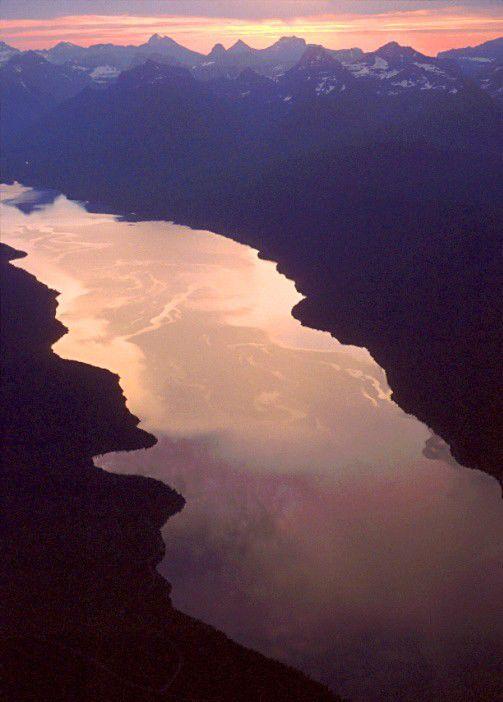
Photos: Breathtaking aerial photographs of Montana rivers and lakes
Breathtaking aerial photographs of Montana rivers and lakes
Big Lake aerial

An aerial view shows Big Lake filled with water. The shallow lake near Molt is in the Halfbreed N.W.R.
Bighorn Canyon aerial

Snow covers the Bighorn Canyon National Recreation Area and the Pryor Mountains in this aerial view.
Bighorn Canyon aerial

An aerial view shows Bighorn Lake at full pool.
Black Eagle Dam aerial

The Missouri River roars over the Black Eagle Dam in Great Falls.
Canyon Ferry aerial

An aerial view shows the Missouri River flowing into Canyon Ferry Reservoir near Helena in this aerial view.
Confluence of the Bighorn and Yellowstone Rivers

An aerial view shows the confluence of the Yellowstone and Bighorn Rivers.
Cooney Reservoir aerial

The sun rises over Cooney Reservoir near Boyd in this aerial view.
Earthquake Lake aerial

Earthquake Lake was created by the landslide seen in this aerial photo. The visitor center sits atop the slide debris
Ennis Lake aerial

An aerial view shows Ennis Lake on the Madison River.
Flathead Lake aerial

The community of Polson and Flathead Lake in an aerial view.
Fort Peck aerial

An aerial view of the the Fort Peck dam and ice covering the lake.
Fort Peck Lake aerial

The sun rises over Montana's Fort Peck Lake in this aerial photograph.
Hebgen Lake aerial

An aerial view shows Hebgen Lake near West Yellowstone.
Hebgen Lake aerial

Wind blows foam into long strings as storm clouds gather over Hebgen Lake.
Holter Lake aerial

Holter Lake shows the bends of the Missouri River in this aerial photograph near Helena, Montana.
Lake McDonald aerial view
An aerial view shows Lake McDonald in Glacier National Park.
Milk and Missouri rivers

Boaters run through the mixture of Milk and Missouri River waters near the confluence below Fort Peck Lake in this aerial view.
Mission Creek aerial

Mission Creek dumps milky water into the clear Flathead River near the town of Agency in this aerial view.
Missouri RIver aerial

The Missouri River winds toward Great Falls in this aerial view.
Musselshell River and UL Bend National Wildlife Refuge

The UL Bend National Wildlife Refuge, shown here surrounded by water on three sides, is just north of where the Musselshell River, at lower right, flows into Fort Peck Reservoir. This aerial view was shot in June 2015.
Mystic Lake aerial

Snow and ice covers Mystic Lake in early June during an unusually cool spring in 2011.
Nelson Reservoir aerial

The sun rises over the shoreline of Nelson Reservoir in this aerial view near Saco.
Seli’š Ksanka Qlispe’ Dam aerial

Aerial view of the Seli’š Ksanka Qlispe’ Dam (formerly known as Kerr Dam) on Flathead Lake near Polson.
Tiber Dam aerial

Tiber Dam forms Lake Elwell in this aerial view.
Yellowstone River aerial

An aerial view shows the Yellowstone River winding past Billings.The undammed river provides countless opportunities for recreation in the Billings area.
Yellowstone River aerial

The Yellowstone River flows past Young's Point near Park City.


